Historic Sites and Monuments Board of Canada
Railway Station Report
Title: |
Canadian National Railways West Toronto Station
Toronto, Ontario |
Source: |
Staff Report, Heritage Railway Stations Division |
RSR-141
Introduction
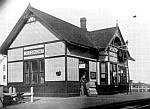
The Canadian National Railways (CNR) West Toronto station at 190 Old Weston Road (Figure 1) in Toronto was built in 1907 by the Grand Trunk Railway (GTR) as part of a general upgrading of facilities carried out in the first decade of the century. Representative in design of a body of stations built in these years, the West Toronto station is significant historically for the development of the western side of Toronto (Figures 2-3). As one of three railway depots in the Junction Triangle of Toronto where a quarter of the working population was employed by the railways, West Toronto station is the last surviving architectural landmark of that important industry.
Abandoned by VIA Rail in 1989, the station sits derelict and boarded up beside the main line used by GO Transit and CNR freight trains.
Historical Associations
Thematic
Emerging from an atmosphere of brisk efficiency and corporate restructuring, the West Toronto station can be seen as an exemplar of the GTR's competitive policies. The years from 1895 to 1914 were ones of optimism and dedicated activity in the railway industry. For the GTR in particular, the appointment in 1896 of American railroadman Charles M. Hays as General Manager ushered in a phase of modernization in business practises and improvement of assets. At the same time, the active intervention of the federal government, which had characterized Canadian railway management since its inception, reached new levels of corruption and interference.1 Measured by his success, Hays brilliance lay in his ability to circumvent the circumstances and build up a company with some possibility of financial viability.2
Hays started the company on its 20th century expansion by challenging corporate policy, which had been unalterably limited to the principle of dividends, not growth.3 Consequently, the railway had been burdened with obsolete rolling stock, deficient stations, and inadequate transshipment systems. Hays instituted a line and staff organization in place of the former line system; purchased over a thousand new cars; rebuilt bridges, closed unprofitable depots, and constructed new Montréal headquarters buildings, under the guise of routine maintenance accounts. By 1906 the company had virtually doubled their track from Chicago, through Sarnia and Hamilton to Montréal, and back. The resultant 872 miles was the longest stretch of continuous double track under one railway management in the world.4 Each year, the company built about 20 new stations in Ontario, Most of these replaced existing buildings.
After about 1904, the company image as reflected in its stations was noticeably related to long-established trends in industrial construction. Small second-class stations like West Toronto were once again built in fire resistant masonry materials, as the first generation of GTR stations had been in the 1850s, and the occasionally romantic qualities of the late 19th century buildings were forsaken for simple massing, smooth planes, and utilitarian functionalism. The reorganization of the company also seems to have affected the way plans were implemented locally for new stations. The ten or more standard plans for typical railway buildings were apparently consulted for a repertoire of forms and finishes, but in Ontario they were not built according to the book. The West Toronto station has peculiarities of plan and external elevation that are believed to be unique to the site.
The role of the GTR in establishing community economies and landscapes was almost incidental by the time this station was constructed. The social and physical cultures of West Toronto had been formed entirely by the situation contingent on three railways intersecting, and the remarkable environment around the West Toronto station is testament to those conditions. In the larger context of the GTR, the station is an emblem of the company's first years of comparatively modern organization, new business methods, and rationalization of activities.
Local Development
The founding of the community of West Toronto Junction was rooted in purely commercial interests, and its sustenance relied heavily on the railways. The principal speculator, Daniel Clendenan, was drawn to the area in 1883 by the possibility of making lots of money in proximity to railway development.5 Four separate railway lines through the area in 1880 created a junction diamond, and more were contemplated. The Credit Valley and Toronto, Grey and Bruce (TG&B) railway companies as well as the GTR tracks ran parallel into the area between Bloor and St. Clair streets (St. Clair was then called Davenport); the Northern turned north farther east, to the Davenport station, and planned another line that would have bisected High Park (Figure 4).6 The Ontario and Québec line, running across the northern fringes of the city, terminated at the Junction. It was acquired by the Canadian Pacific Railway (CPR) in 1881, as were the Credit Valley and TG&B.7 The TG&B had a station below Davenport Road, near a community known as Carlton, and the CPR built a station at the junction of their two branch lines in 1884.8 The Junction became strategically important when the CPR reached Ottawa.
GTR presence in the area was fairly limited in the 19th century. After the amalgamation of the GTR with the Great Western Railway in 1882, the GTR line running through West Toronto was demoted to secondary status in favour of the Great Western's lakeshore line to Hamilton.9 The GTR did not have a station in the area, but carried passengers from a flag stop at Royce Avenue (the present Dupont), apparently until the construction of a station in 1898.10
The combined effects of speculative and industrial activity were dramatic. During the winter and spring of 1883-84, over 400 lots had been sold (averaging just over two lots per purchaser), more than 20 buildings were underway, and 1500 shade trees had been planted.11 To gain the autonomy necessary to issue bonds and raise taxes, in 1887 West Toronto incorporated as a village to increase its allure in negotiations with the CPR. That company had offered to move its railway shops to the Junction from the lakeshore line at Parkdale in exchange for tax exemption, costly road work, and unlimited free water in a place that had no services. As a possible indication of who ran the town, the celebration party for incorporation was held in the CPR station dining room.12 An additional area the size of the original town was annexed in 1889, incorporating the site of the GTR station, when West Toronto Junction established itself as a town.13
With its junction station, freight yards, and shops, the CPR dominated the economic life of the town. The GTR station was not a junction point for the company, but was a freight station in the heart of Toronto's industrial suburb. Company records indicate that a freight shed was built in the area in 1854, when the rails went through. A platform was built in 1875, and by 1890 the company had built several sidings in the Junction. The full panoply of buildings was constructed in 1898: station and baggage room, closet
, and car repair shop, all modest frame structures with timber foundations and shingle roofs.14
The GTR was not committed to developing the town. Corporate ambitions for a transcontinental line that would carry the products of the western prairies sparked the company's protest when the city stockyards located 600 feet from their depot. GTR refused to build a siding paid for by the stock yards; they declined shipments of live stock from the Junction and apparently tried to influence industries not to set up in the area.15 Their protests were ignored, but the company's attitudes may account for the negative editorials and lack of mention they received in the local press.16
A single imperative is believed to have instigated the flurry of construction in 1898. In the 1890s the Junction was already suffering financial reversals from the general depression, a shaky bond issue, and low tax revenues. A Cleveland bicycle manufacturer set up shop in an empty iron works factory, employing 700 workers and renewing a degree of prosperity. As a result of that company's lobbying, West Toronto was deemed a federal customs port in 1898 to facilitate shipment into and out of the town. At the time, Toronto was the only city in North America with two ports of entry.17 The benefits for the railways are evident. Foreign shipments could be cleared more quickly, with less movement of cars, than at the downtown yards, and the port attracted more industries, which provided more rail business. The GTR could not overlook the competitive advantages of the Junction location.
Transportation facilities were critical to industry, but booster brochures featured only the CPR facilities.18 In the years after 1900, production continued to boom in the Junction. Over 2000 employees (about a third of the total population) worked in a dozen heavy industries and factories, including engine works, motor works, oil works, brick works, soap works, flour mills, foundries, the Heintzman piano company, and the railways, which accounted for a quarter of all employment.19 An impressive urban core was built, with one outstanding corner bank building by the New York firm of Carrere and Hastings.
In addition to its customs port and architecture, the town was distinguished by its support in 1903 for local option
. In that year, every outlet for intoxicating liquor
was closed, and the 1600 acre area of the town has been dry
ever since.20 Every subsequent attempt to repeal the by-law has been overturned; the most recent was in 1983.
West Toronto amalgamated with Toronto in 1909. Talk of the amalgamation had been the impetus for the town to change its name to the City of Toronto Junction in 1908, and may have been a factor in the construction of the new GTR station in 1907. Railway activities continued to define the character of the area through the 20th century, and the distinctive physical landscape is still heavily redolent of railway activity (Figure 5). Streetscape improvement campaigns have capitalized on the railway motif, but the West Toronto station itself best signifies the origins and history of the area.
Architecture
Aesthetic/Visual Qualities
In its incorporation of standard GTR motifs coupled with slight irregularities in plan and elevation, the West Toronto station exemplifies the site-responsive approach to construction adopted by the company after 1900. The station was built in 1907 of oversized vitrified brick.21
Roof lines are the organizing factor in expressing and ordering the building volumes (Figure 6). The familiar peaked gable above a flared hip, with low polygonal turrets on projecting bays, characterized the GTR stations built in this decade. At West Toronto, the pavilion of the station body is joined by a relatively long freight shed, with a slightly lower roof. The station proper has three distinctive elements: the projecting bay enclosing the passenger waiting room that faced south down the infinite parallel of the CPR and GTR tracks; the matching operator's bay on the west side, continued through the roof as a glazed look-out under a lifted roof cap; and the vagaries of the plan, externally expressed by the three doors on the track elevation (Figures 7-8).
This general form, and its means of expression, were commonplace for southern Ontario GTR stations in the period after 1904, but only a small urban cluster survives in any shape or form.22 Vitrified brick, with a hard speckled surface and gritty colouring, was the newest feature to separate these stations from their board and batten country cousins. The exceptionally large units used here are an unusual choice for so small a building (Figure 9). Another element was the semi-octagonal look-out above the operator's bay, a punctuation device adapted to the roof profile that was comparable to the ornamented gables of the little wooden pavilions of a decade before (Figure 10). Perhaps the most signal aspect of the design is the roof itself, with its modest little eaves kick alluding to the French bell-cast that was being so opulently exhibited on the chateau inspired railway buildings of the CPR.
The waiting room with a view is an element rarely encountered in station design, since few sites offered the dramatic relationship to the tracks that West Toronto did. At Palmerston, an important yard and junction on the Ontario Middle Division, an elegant ladies' waiting room was added in 1900 with exactly this position between approaching tracks. There, the curved bay was entered through a pillared arch and the women's rest room adjoined. The remnants of original partitions which now survive as spur walls at West Toronto could indicate a similar plan (Figure 11).
Two factors make the original plan very difficult to discern: the renovation of the building to serve different rail purposes, and the dreadful dereliction into which the station has fallen.
Interior inspection is limited by the complete absence of light: all the openings are boarded up and there is no electrical service. Externally, the roof has disintegrated at the eaves in two places (Figure 12). The brickwork is sound, but it is probably being affected by this exposure. The north freight end is separate from the office and waiting room; and can be entered only through the outside doors. It is presently divided into two spaces, both littered with debris (Figures 13-14). The office and lobby wing consists of two principal spaces, but they probably do not conform to early usage (Figure 15). Three doors on the track elevation for this section imply a plan somewhat different from the standard divisions. A third space, a narrow slot termed an after hours waiting room
in a 1977 inspection, is inaccessible, and reached only by one of those outside doors. Since the covering of openings makes it difficult to determine how alterations have occurred, the evolution of this station may not be usefully understood until the building is fully opened again.
Thanks to its bold masonry construction and prominent rooflines, the form, colours, textures, and materials of the West Toronto station are fairly represented by the present appearance of the building.
Functional/Technological Qualities
The planning and the site of the station worked together particularly well in this instance, set as it is virtually in the road allowance. The passenger waiting room is oriented with a dramatic view south down the track toward the junction triangle, where the steaming engines could have been spotted well in advance of their arrival (Figure 16). Industry, carters, trucks, and passengers all had equal access.
The layout of the interior is not completely clear, however, because of the overlay of later materials. The only plan available is inaccurate, and does not correspond with the present interior in two key respects.23 There is no office partition as shown, and spur walls separating the lobby bay, not shown on the plan, have been extended as a complete partition (Figures 11, 15). With three doors around the operator's bay, it is not clear which one was for passenger use. The narrow space called after hours waiting room
is not presently accessible, indeed, the north and south parts had to be broken in to by CNR staff for inspection. That room may have been a smoking room, a file room, or may have been somehow connected with the baggage facility on the other side of the wall.
Whatever its original configuration, the station was not a model of modern planning, but rather a small sub-station for commuter traffic and freight. None of the prescribed amenities, such as dining rooms or concessions, seem to have been offered, and the layout may have been inconvenient for staff if they were separated, as seems probable, from all freight and baggage handling.
The glazed bays, large windows, and relatively generous spaces suggest that the station may have been comfortable and commodious for the travelling public.
Environment
Setting
The station environment vividly exhibits the presence of the railways in the 19th century city. Like most stations of the period, tracks ran on both sides, but here they represented two separate companies, and sliced across roads and factory sites, and carved scars across the western edge of Toronto that still determine the street patterns and the price of housing. This short stretch of Old Weston Road has the quality of some forgotten place near the edge of the urbanized world. Crumbly row-housing squats along the road opposite the station. An ominous, permanent Bridge Out
sign bars the south end of the street, although the tracks strike off through a no-man's land toward distant apartment towers (Figure 17). Enormous elevators loom over trackriven Junction Road, and the skyline is spiked by the exhaust towers of low factory buildings, formerly a foundry, lining the west track. The station floats out toward the street, and swings startlingly into view as the multiple level crossings are navigated from the south (Figure 18). Originally, Weston Road connected with Dundas Street, bridged the railway lines, and was not the peripheral side street it has become. The Weston Road crossing was the worse of two of the most dangerous level crossings one could imagine
.24
Old Weston Road is a short-cut to St. Clair in an area where traffic is always busy and frequently heavy. The industrial zone first engendered by the railway is now largely supported by trucking: vast slaughter houses, meat-packing plants, and chemical factories render the area unpleasant and even dangerous for residents. Nearly all the factories still have railway sidings, but trains are rarely met by traffic—except on the CNR main line beside the West Toronto station.
The platform itself is very long, with a disused, two-storey brick CNR office block occupying the northern end (Figure 19). The setting brings together the railway with the urban in a way that was seldom attempted and which rarely survives. The factory and stockyard presences that dominated the Junction are still large components in the landscape; the streets parallel and intersect with the rail lines, which determined the existence of the town; and workers' housing fills the interstitial spaces between them. The CNR station is the pivotal nexus where these three elements intersect. The station is a very visible relic of active railway industry in the area.
Community Status
The station building is listed on the Inventory of the Toronto Historical Board, but the city lacks authority to issue work-orders on the building. Although the station does not have a high profile in the community, due to its location and the rather disparate demographic profile of the area, its condition is of concern to railway buffs, the community newspaper, and local activists. The West Toronto Junction Historical Society has made numerous efforts to negotiate with CNR but has not had any success in getting to the discussion stage. They hold hopes for the reuse of the station on or near its present site, ideally for rail passengers.25 Since the loss of the CPR station in 1983, the CNR station has assumed even greater importance as the only remaining building with any historic and visual association with the railway.
The station was the subject of a conceptual site-specific artwork dealing with themes of perception and transformation, undertaken as part of a local initiative in 1992. Artist Kathryn Walter's brochure posed the question, what history is being valued in this transformation [of the station from transportation use to heritage value]?
She concluded, Perhaps the Junction can be seen as a point of departure to consider its history in relation to our present social structure
(Figure 20).
EndNotes
- ^ Although Laurier's Liberal government supported the railway and its transcontinental line, the tendering process established by the railway commissioners for the Grand Trunk Pacific, and the subsequent disregard of departmental regulations, provoked the resignation of the Chief Government Engineer in 1909. The Liberals were defeated in 1910, largely due to the ensuing scandal. Approximately 43 per cent of the cost of the $161 million line, or $70 million, was wasted or stolen, G. R. Stevens, History of the Canadian National Railways (New York: Macmillan Company, 1973), pp. 200-14.
- ^ A. W. Currie, The Grand Trunk Railway of Canada (hereafter The Grand Trunk Railway) (Toronto: University of Toronto Press, 1957), pp. 371-75.
- ^ Stevens, History of the Canadian National Railways, p. 192.
- ^ GTR Semi-Annual Report, 6 April 1906, quoted in Currie, The Grand Trunk Railway, p. 422.
- ^ Joan Miles, ed., West Toronto Junction Revisited (Erin: Boston Mills Press, 1986), p. 13. The book is a compilation of the memoirs of A. B. Rice, the local newspaper editor in the period from 1889 to 1904.
- ^ Christopher Andreae, "Railway Heritage in Torontow (London: Historica Research Limited for the City of Toronto, 1983), pp. 21-25.
- ^ Andreae, Railway Heritage in Toronto, p. 24.
- ^ Miles, West Toronto Junction Revisited, p. 15, citing a notice in The Globe (Toronto) of 14 April, 1884. It was the unauthorized demolition of the second CPR station in West Toronto that eventually lead to the Heritage Railway Stations Protection Act.
- ^ Andreae, Railway Heritage in Toronto, p. 23.
- ^ Railway timetable published in The Daily Tribune (7 October 1893), n.p. A partial copy of the paper is in the files of the West Toronto Junction Historical Society at Annette Street branch of the Toronto Public Library.
- ^ Miles, West Toronto Junction Revisited, p. 15.
- ^ Miles, West Toronto Junction Revisited, pp. 18-19.
- ^ In June 1891, the council voted to remove the word
West
from their name, and a year later requested GTR to change the name of their Carlton station to Toronto Junction, and that of Davenport to Toronto Junction East. Town Council Minutes 22 June, 1891, and 6 June 1892. Courtesy Barbara Myrvold, Toronto Public Library.
- ^ Grand Trunk Railway System, Bridges and Buildings, Middle Division ([Montréal]: 1907), p. 148. On fire insurance maps, the station was designated
Western Carlton
. Goad's Atlas of the City of Toronto and Vicinity, 1890, plate 40.
- ^ West Toronto Junction Town Council Minutes, 15 May, 1903. Courtesy Barbara Myrvold, Toronto Public Library.
- ^ There are no local papers extant for the time in which the present station was constructed. Toronto papers that had offices in the Junction, such as the Toronto World, frequently mentioned CPR doings, but the GTR was totally ignored.
- ^ Miles, West Toronto Junction Revisited, p. 52. The customs building was not beside the railways, however, but at Keele and Dundas, in the centre of the town.
- ^ Copies of several pamphlets in the local history files of the Annette Street branch of the Toronto Public Library are free of any reference to the GTR.
- ^ Miles, West Toronto Junction Revisited, pp. 55, 60. Canadian Railway and Marine World (CRMW) (November 1907), p. 801.
- ^ A. B. Rice quoted in Miles, West Toronto Junction Revisited, p. 67.
- ^ "GTR Development" CRMW (August 1907), p. 599. "A new permit has been issued for erection of a new station, to cost $2500., at Toronto Junction, Ontario. It is to be of brick, 65 by 28 feet." From this description it is not clear whether the station was built as and when stated. The present dimensions are thought to be 77 by 22 feet.
- ^ Similar stations exist at Mimico (1917), St. Clair (1931), both in Toronto, and St. Marys (1912).
- ^ Dated 1977, it is from Ontario Ministry of Citizenship and Culture railway files. It is consistent in style with a number of other station plans in Ministry files, but their source is not credited.
- ^ Miles, West Toronto Junction Revisited, p. 29.
- ^ Joan Miles, Past President of the West Toronto Junction Historical Society, in conversation with the author, 23 August, 1992.
Figures
- Canadian National Railways West Toronto station, Toronto, Ontario, built in 1907 by the Grand Trunk Railway. West elevation. (Heritage Railway Stations Division [HRSD] files, 1991.)

- West Toronto Junction in relation to Toronto railway lines. (Railway Map of Southern Ontario [Guelph: Clyde Publishing, 1985].)
Image Not Available
- Map of the Junction area showing the CPR station before its destruction, and the CNR station in black. (Property Data Map 23, City of Toronto Planning Board, 1970.)
Image Not Available
Plan of the Subdivision of Parts of Lots 36, 37, 38 and 39 ... Formerly known as the Carlton Park Race Course
by Unwin, Brown & Sankey for D. W. Clendenan and D. J. Laws, Toronto, February 27th, 1883. Detail of the West Toronto Junction area. (National Archives of Canada, National Map Collection 0051814.)
Image Not Available
- Map of the West Toronto Junction in 1910 showing the interrelation of industry, rail lines, and residential properties. (Charles E. Goad & Company, Atlas of the City of Toronto and Vicinity [Toronto: 1910], plate 64.)
Image
- CNR West Toronto station, east elevation. (HRSD files, 1991)

- CNR West Toronto station, south bay enclosing former waiting room. (HRSD files, 1991)

- CNR West Toronto station, west side showing operator's bay. (HRSD files, 1991)

- CNR West Toronto station, detail of masonry on south bay. (HRSD files, 1991)

- GTR station at Caledon East, Ontario, built after 1907. (Region of Peel Archives, N 239-4.)
- CNR West Toronto station, interior of central space looking to a partition wall on the south end that replaced an earlier partition. Early baseboards are visible on each side. (HRSD files, 1992)

- CNR West Toronto station, detail of deterioration at the eaves. (HRSD files, 1992)

- CNR West Toronto station, partition between rooms in north half. (HRSD files, 1992)

- CNR West Toronto station, corner of room in north half. (HRSD files, 1992)

- CNR West Toronto station, plan in 1997, overlaid with corrections noted during an inspection in 1992. (Ministry of Citizenship and Culture files.)
Image Not Available
- View looking south from the CNR West Toronto station, with tracks on both sides. (HRSD files, 1991)

- CNR West Toronto station, panoramic view from the south. (HRSD files, 1992)

- CNR West Toronto station, panoramic view from the south. Old Weston Road is in the foreground. (HRSD files, 1992)

- CNR West Toronto station and platform from southwest, with railway office at north end of platform. (HRSD files, 1991)

- Brochure representing a work of conceptual art involving the CNR West Toronto station, by artist Kathryn Walter in 1992.
Image Not Available